Counting Wrecks: Visualizing T.A. Scott’s salvage work, 1879-1902

This summer I updated my database of T.A. Scott’s rescue and salvage work for the period between 1879 and 1902. After not thinking much about this data set for three years, I plunged back into historical newspaper databases (much expanded and improved in just a couple of years) and added more than 50 events to the database. I’m sure there are more Scott salvage jobs still hiding in obscure newspapers, but I’m feeling pretty confident I found the vast majority. All told, the database includes 247 separate rescue or salvage events. It’s not clear how many he personally supervised (contemporaries often seemed to conflate Scott the man with Scott the salvage company), but I think it safe to say he was personally involved in most. The database includes the month, year, type of vessel involved in the incident, the vessel’s name, the type of wreck (founding, stranding, ice, fire, damaged), and whether or not it was recovered or repaired. After cleaning up the database with OpenRefine, I used Excel and Tableau Public to create the initial visualizations below. I’m working up some fancier ways to display this data… look for those soon.

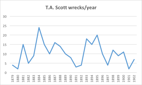
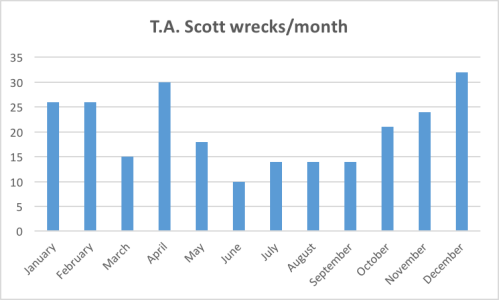
The first two graphs show the annual and seasonal variation in Scott’s salvage work. Marine salvage was anything but steady and the wide variation in salvage work belies just how important non-salvage activities must have been to the T.A. Scott Company. Winter and spring were his busiest salvage seasons. Summer activity was slower because there were fewer wrecks and because he focused resources on lucrative (and relatively steady) marine construction jobs. I want to plot Scott’s work against the number of reported incidents in eastern Long Island Sound to see if there is any correlation between number of wrecks/incidents and his salvage activity.

scott-wrecksperyearscott-wreckspermonth

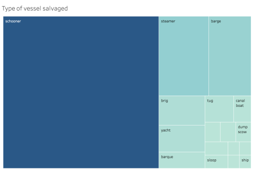
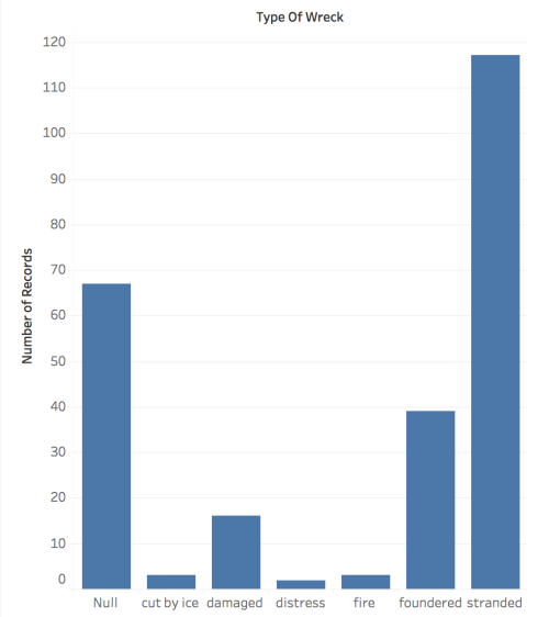
Other trends emerge as we dig into the data. Most notably, the bulk of Scott’s salvage work involved stranded schooners. Steamers and barges were tied for a distant second and an eclectic mix 13 other vessel types took up the remainder. Second, we have large gaps in the data — we do not know, for example, the “type” of wreck for 67 incidents. Possibly with further research we’ll be able to fill in these blanks. (to explore the graphs click here and here.)

screen-shot-2016-09-12-at-12-14-22-pmscreen-shot-2016-09-12-at-12-15-13-pm

More to come soon…

Leave a comment

Filed under Notes from the Field

Summer in New London: T.A. Scott and the New London Maritime Society

Fall is here; classes have begun. But I’m certainly not ready to give up summer, and so we’ll reminisce. Two months ago I gave a pair of talks at the New London Custom House for the New London Maritime Society. My time there got off to a fantastic start — lunch at Captain Scott’s Lobster Dock. Not only was the lobster roll divine (maybe I have been too south for too long), but I also met a direct descendant of Captain Thomas A. Scott, the Dock’s namesake and the topic of my first talk: Chasing Scott: Researching New London’s ‘Master Wrecker.’ There was a great turnout for a mid-week afternoon talk and an overwhelming interest in the man I’ve been researching for a long, long time. I think a biography would be great fun…

After making plans to connect with Scott’s heir during the New London off-season, I whiled away the afternoon in the Maritime Society’s wonderful archive. Susan Tamulevich, the director, was a wonderful host, and I look forward to going back and spending some serious research hours in their library. I also had the pleasure of meeting David Zapatka. Zapatka was taking down his amazing photography exhibit “Stars and Lighthouses”–a collection of wondrous non-Photoshopped images of lighthouses lit at night with stars in the background. I’ve looked at a whole lot of lighthouse photographs and I’ve never seen any like these.  Check them out — I’m saving up for a print.

The evening talk had another nice audience and a great discussion. I jabbered about my current book project, which I’m now tentatively calling Shipwrecks and the Making of the Modern Beach. The talk was an opportunity for me to take that difficult step back and try to give a coherent overview of the project. It was a difficult, but invaluable and has helped me immensely as I put together the book proposal.

In the next post, I’ll share some of the research and graphics I finished up this summer on the illustrious Captain Thomas A. Scott.

Leave a comment

Filed under Notes from the Field

Coastal Research Prize

Screen Shot 2016-04-20 at 7.53.44 AMDefining “the coast” is notoriously difficult. I tend to favor a broad, inclusive definition and always seem to fall back on John Stilgoe’s concise articulation: “Between deep sea and ordinary inland landscape.” I loved his  provocative exploration of the Massachusetts coast in Alongshore and how his definition captures both the fluidity of the coastal environment and the importance of subjective experience to understanding it. Look out for a future post where we tease out some of the implications of that definition. But suffice to say that “the coast” reaches far beyond that ever-shifting line where water meets land.

I’ve recently been thinking a lot about what “coastal research” entails. Part of my postdoc involves facilitating collaborative “coastal” projects by  folks from the hard sciences, social sciences, and humanities. Look across most universities and you see a whole bunch of folks studying the same space from radically different angles. What would happen if we got all those researchers in a room? What could be gained from putting an environmental scientist interested in barrier beaches, with a biologist interested in sea turtles, with a social scientist interested in beach tourism, with a coastal historian, with local activists and policy managers? I’d sure like to find out.

The biggest challenge to starting this trans-disciplinary conversation is identifying scholars across a university who are doing “coastal” work. Some of these researchers have a clear coastal research agenda with a strong funding streams and disciplinary support. Others working on what might be considered a coastal project don’t consider their work “coastal.” And some scholars doing self-identified coastal projects are working on the margins (pun intended) of their field.  Take my discipline, history. “Coastal history” (a term I self-conscisously avoided when writing my dissertation for reasons not worth getting into here) is getting some traction due in large measure to the tireless work of Isaac Land, the Port Towns & Urban Cultures group out of the University of Portsmouth, and several others (hint: follow #coastalhistory to follow this growing conversation on Twitter). But many, many historians are doing work that could be categorized as “coastal” if we applied Stilgoe’s definition.

So how can we find scholars working on coastal projects? Their students. The “Coastal Research” badge (posted above) will be placed on every “coastal” project at tomorrow’s Student Scholar’s Symposium at the University of West Florida. A certificate will be awarded to the undergraduate judged to have the best coastal poster presentation. We hope to highlight coastal research being done by UWF undergraduates, encourage more coastal research (fingers crossed on a monetary award next year), and begin that trans-disciplinary conversation. Until then, I’m looking forward to judging the posters tomorrow!


2 Comments

Filed under Uncategorized

Mapping the American Coastal Frontier ca. 1800

This slideshow requires JavaScript.

The last post explained how to use QGIS and historic census data to map population density. This post gets to that tricky “so what?” question.

So why map population density in 1800? My current project examines the social, cultural, and physical transformation of the American coast (my shorthand for coast of the United States of America) over the course of the long nineteenth century. I’m primarily interested in the oceanfront between ports, harbors, and the huge natural bays and sounds, that many a European explorer thought led to China, and how they became such a central—arguably essential—part of the American experience.

I’m currently slogging through the first chapter, a survey of the American coast on the eve of its transformation. It’s partly inspired by Marcus Rediker’s magisterial first chapter in Between the Devil and the Deep Blue Sea and similarly favors fruitful generalization over burdensome qualification. An important subargument of the chapter is to establish the 1800 American coast as a frontier. Well…maybe I do a bit of hair-splitting in the chapter. In any case, one of the many ways to define frontier is through population density. Hence, our maps.

Continue reading

2 Comments

Filed under Notes from the Field

How to Map Historic Census Data with QGIS

1800 modcomp largewcities
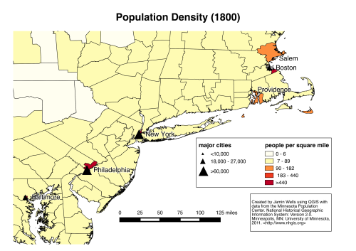
Ten years ago I took an introductory Geographic Information Systems (GIS) class. It was a bit mystifying (as those technical courses can be to us humanities folks) but I could see the potential. I’m sorry to say that the ins and outs of ArcGIS faded from memory as I ran that marathon of coursework, comps, prospectus, etc., etc. Yes, I actually reverted to paper maps, highlighters and, yes, dear reader, I used thumbtacks. It worked for what I needed then, but I need a bit more now.

Maps answer questions. The questions my maps need to answer are really important to my larger project: How many people lived on the American coast? Where did they live? What was the coast’s population density? And how did it change over of the nineteenth century? I tried google and as you might surmise, no good hits. So I cracked open my computer and spent too much time piecing together advice and how-to guides as I stumbled through making my first GIS maps. What follows is how I did it. Why? Honestly, I want to have the directions handy when I’m trying to do this again in a year or two. Secondly, maybe this post can help some uninitiated humanities researcher dip their toes in GIS joy. This post explains how I made the maps above. The next post will analyze them.

Continue reading

Leave a comment

Filed under Uncategorized